Garden Design: First make a site plan
Make a site plan
(extract from the book: Australian Plants for Canberra region gardens)
The site plan should show:
- all buildings and obstacles that create shade, including winter and summer shade patterns
- driveways and existing paths
- any features (rocks etc) or vegetation worth retaining
- any underground or overhead easements and services to the property and their limitations
- the slope and aspect of your site
- existing microclimates (see also step 4)
- the position of water tanks, run-off swales (permeable water courses) and, if required, irrigation systems
- the position of your neighbour’s structures and associated limitations.
Graph paper is very helpful in drawing to scale. Once the fixed features have been added to your site plan, you can use tracing paper taped over the site plan to play with the endless possibilities — keeping the original drawing free from markings — until you find a satisfactory design. It is helpful, if possible, to observe your site over some months to work out sun, wind and shade patterns on your site.
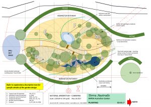
This is an example of a site plan for a small garden at the National Arboretum Canberra showing the location of major features. This garden is all native plants representing different regions of the country.